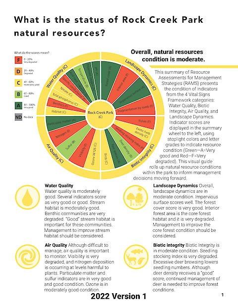
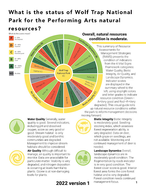
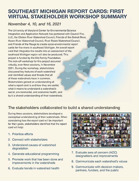
Publications by Dylan Taillie

IAN is committed to producing practical, user-centered communications that foster a better understanding of science and enable readers to pursue new opportunities in research, education, and environmental problem-solving. Our publications synthesize scientific findings using effective science communication techniques.

Southeast Michigan Report Cards: First Virtual Stakeholder Workshop Summary (Page 1)

Southeast Michigan Report Cards: First Virtual Stakeholder Workshop Summary

November 4, 10, and 16, 2021

Dylan Taillie, Alexandra Fries, Heath Kelsey, Joe Edgerton, Lorena Villanueva-Almanza ·
4 January 2022

The University of Maryland Center for Environmental Science Integration and Application Network has partnered with Council Fire, LLC, the Clinton River Watershed Council, Friends of the Detroit River, Huron River Watershed Council, River Raisin Watershed Council, and Friends of the Rouge to create socio-environmental report cards for five rivers in southeast Michigan. An overall report card that integrates the results into an assessment of the southeast Michigan region will also be produced.

Read more

USGS Chesapeake Science Strategy 2021-2025 (Page 1)

USGS Chesapeake Science Strategy 2021-2025

Hyer, K., Phillips, S. ·
2 July 2021

The Chesapeake Bay ecosystem is a national treasure that provides almost $100 billion annually of goods and services. The Chesapeake Bay Program (CBP), is one of the largest federal-state restoration partnerships in the United States and is underpinned by rigorous science. The U.S. Geological Survey (USGS) has a pivotal role as a science provider for assessing ecosystem condition and response in the Chesapeake watershed.

Read more

2020 Mississippi Rivers Report Card Methods (Page 1)

2020 Mississippi River Watershed Report Card Methods Document

Heath Kelsey, Katie May Laumann, Vanessa Vargas-Nguyen, Sky Swanson, Steven Guinn, Dylan Taillie, Joe Edgerton, Andrew Elmore, Jane Hawkey ·
27 April 2021

This companion document to the 2020 Mississippi River report card contains information about data sources for all indicators, summary of analysis methods, and scoring details for each of the six America’s Watershed Initiative goals, and for two watershed wide indicators. Additional information regarding the goals is included to provide greater detail and discussion than is possible in the report card document.

Read more

Nutrient Trends and Drivers in the Chesapeake Bay Watershed (Page 1)

Nutrient trends and drivers in the Chesapeake Bay watershed

Hyer KE, Phillips SW, Ator SW, Moyer DL, Webber JS, Felver R, Keisman JL, McDonnell LA, Murphy R, Trentacoste EM, Zhang Q, Dennison WC, Swanson S, Walsh B, Hawkey J, Taillie D ·
26 January 2021

The Chesapeake Bay Program maintains an extensive nontidal monitoring network, measuring nitrogen and phosphorus (nutrients) at more than 100 locations on rivers and streams in the watershed. Data from these locations are used by USGS to assess the ecosystem’s response to nutrient-reduction efforts.

Read more

Anthropogenic, Direct Pressures on Coastal Wetlands (Page 1)

Anthropogenic, Direct Pressures on Coastal Wetlands

Newton A, Icely J, Cristina S, Perillo GME, Turner RE, Ashan D, Cragg S, Luo Y, Tu C, Li Y, Zhang H, Ramesh R, Forbes DL, Solidoro C, Béjaoui B, Gao S, Pastres R, Kelsey RH, Taillie D, Nguyen Nhan N, Brito AC, Lima RD, Kuenzer C ·
2020

Coastal wetlands, such as saltmarshes and mangroves that fringe transitional waters, deliver important ecosystem services that support human development. Coastal … wetlands are complex social-ecological systems that occur at all latitudes, from polar … regions to the tropics. This overview covers wetlands in five continents. The wetlands … are of varying size, catchment size, human population and stages of economic … development.

Read more

2019 Chesapeake Bay & Watershed Report Card (Page 1)

2019 Chesapeake Bay & Watershed Report Card

Alexandra Fries, Sky Swanson, Dylan Taillie, Caroline Donovan, Max Hermanson, Heath Kelsey ·
19 May 2020

This report card provides a transparent, timely, and geographically detailed assessment of Chesapeake Bay. Since 2016, UMCES has engaged stakeholders throughout the watershed to transform the report card into an evaluation of the Chesapeake Watershed health. Watershed health includes traditional ecosystem indicators, but also social, economic, and cultural indicators. This is the first year the watershed has been scored, using five indicators of ecological and socioeconomic health.

Read more

Water quality gradients and trends in New York Harbor (Page 1)

Water quality gradients and trends in New York Harbor

Taillie DM, O’Neil JM, Dennison WC ·
2019

New York Harbor is a complex of interconnected waterways that have supported the rapid development of a thriving megacity and metropolitan region. The water quality of New York, a partner city in the World Harbour Project, is a reflection of the combined impacts of this metropolitan region. Water quality health and trends were assessed between 1996–2017 in 9 different reporting regions using publicly available data.

Read more